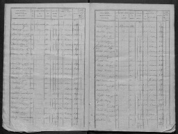
/medias/customer_2/cadastre/3p6/3P6_455/FRAD027_3P6_455_0001_jpg_/0_0.jpg /medias/customer_2/cadastre/3p6/3P6_455/FRAD027_3P6_455_0002_jpg_/0_0.jpg /medias/customer_2/cadastre/3p6/3P6_455/FRAD027_3P6_455_0003_jpg_/0_0.jpg /medias/customer_2/cadastre/3p6/3P6_455/FRAD027_3P6_455_0004_jpg_/0_0.jpg /medias/customer_2/cadastre/3p6/3P6_455/FRAD027_3P6_455_0005_jpg_/0_0.jpg /medias/customer_2/cadastre/3p6/3P6_455/FRAD027_3P6_455_0006_jpg_/0_0.jpg /medias/customer_2/cadastre/3p6/3P6_455/FRAD027_3P6_455_0007_jpg_/0_0.jpg /medias/customer_2/cadastre/3p6/3P6_455/FRAD027_3P6_455_0008_jpg_/0_0.jpg /medias/customer_2/cadastre/3p6/3P6_455/FRAD027_3P6_455_0009_jpg_/0_0.jpg /medias/customer_2/cadastre/3p6/3P6_455/FRAD027_3P6_455_0010_jpg_/0_0.jpg
Accéder au visualiseur des médias : 198 médias

Léry

  • Description :

    1835 Tableau indicatif des propriétés foncières

  • Date :

    1835

  • Identifiant :

    3 P 6 455

  • Localité : Léry (Eure, France)
  • Mots-clés