


Pont-De-L'Arche _ CTRI _ Fond de plan topographique du Groupement régional des villes de Pont-de-l'Arche, Igoville, et Alizay, en 4 feuilles
-
Description :
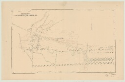
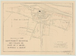
par R. GUITONNEAU, géomètre _ 1942 _ Imprimé, papier, encre noir et bistre, échelle : 1/2000e _ 1- Feuille 1. Igoville _ 101,5 x 65 _ _ 2- Feuille 2. Alizay _ 94,2 x 59,5 _ _ 3- Feuille 3. Route nationale et la Seine (pas de pont) _ 38,5 x 59 _ _ 4- Feuille 4. Pont-de-l'Arche _ 83 x 60 _ _ Fond de plan topographique du Groupement régional des villes de Pont-de-l'Arche, Igoville, et Alizay, regroupant les plans précédents en 1 feuille _ par R. GUITONNEAU, géomètre _ 1942 _ Imprimé, papier, encre noir et bistre, échelle : 1/5000e _ 3 exemplaires : _ 5- 106 x 76 _ 6- 105,5 x 75,8 _ 7- 112 x 76 _ _ Croquis topographique, document de première approximation d'après réduction des plans cadastraux et complété à l'aide de photographies aériennes _ par M. CHAVOUTIER, géomètre _ 1950 _ Imprimé, papier, encre noir et bistre, échelle : 1/5000e _ 8- Feuille 1. Pont-de-l'Arche, Igoville, Alizay, Rouville _ 104 x 74 _ _ 9- Feuille 2. Pont-de-l'Arche, Le Manoir-sur-Seine, Pîtres, Alizay _ 103 x 76 _ _ 10- Feuille 3. Pont-de-l'Arche, Les Damps, Igoville, Alizay _ 103 x 75,7 _ _ 11- Feuille 4. Pont-de-l'Arche, Poses, Le Manoir-sur-Seine, Pitres, Léry, Amfreville-sous-les-Monts, Les Damps _ 104,2 x 75
-
Date :
1942
-
Identifiant :
7 Pl 35
- Localité : Pont-de-l'Arche (Eure, France) ; Alizay (Eure, France) ; Igoville (Eure, France) ; Rouville (Eure, France) ; Damps (Les) (Eure, France) ; Pîtres (Eure, France) ; Poses (Eure, France) ; Manoir-sur-Seine (Le) (Eure, France) ; Léry (Eure, France) ; Poses (Eure, France) ; Amfreville-sous-les-Monts (Eure, France)