
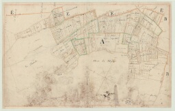


Panilleuse - Plan de la commune. *, Atlas de 5 plans non reliés, datés vraisemblablement de 1789 , établissement du terrier conservé (extrait de 2 F 2882, Marquisat de Clère).
-
Description :
Ces plans s'apparentent aux futures sections cadastrales, avec noms des tenanciers et biens des religieux du Bec, 1789, O. Ms. papier, aquarellé, notes au crayon, rose d'orientation, légendé, encadrement par 2 traits à la sanguine, 1- section A : 79,2 x 50, 2- section B : 75 x 50 (croquis au crayon d'une tête féminine), 3- section C : 79,2 x 49,5, 4- section D : 79,5 x 49,3, 5- section E : 79,2 x 49,6 (plan du village avec manoir et église)
-
Date :
1789
-
Identifiant :
2 PL 128
- Localité : Panilleuse (Eure, France) ; Clère (marquisat de) (Eure, France) ; Bec-Hellouin (Abbaye du) (Eure, France)
-
Autres identifiants :
Ancienne cote : 2 F 2882